


Sixth Ward First Precinct, Petersburg city, Virginia
About
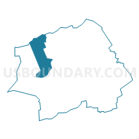
Outline

Summary
| Unique Area Identifier | 683063 |
| Name | Sixth Ward First Precinct |
| County | Petersburg city |
| State | Virginia |
| Area (square miles) | 1.45 |
| Land Area (square miles) | 1.40 |
| Water Area (square miles) | 0.05 |
| % of Land Area | 96.59 |
| % of Water Area | 3.41 |
| Latitude of the Internal Point | 37.21581660 |
| Longtitude of the Internal Point | -77.42191910 |
Maps


Graphs
Select a template below for downloading or customizing gragh for Sixth Ward First Precinct, Petersburg city, Virginia


Neighbors
Neighoring Voting District (by Name) Neighboring Voting District on the Map
- Ettrick Voting District, Chesterfield County, VA
- Fifth Ward First Precinct, Petersburg city, VA
- Fourth Ward First Precinct, Petersburg city, VA
- Seventh Ward First Precinct, Petersburg city, VA
Top 10 Neighboring County Subdivision (by Population) Neighboring County Subdivision on the Map
Top 10 Neighboring Place (by Population) Neighboring Place on the Map
Top 10 Neighboring Unified School District (by Population) Neighboring Unified School District on the Map
Top 10 Neighboring State Legislative District Lower Chamber (by Population) Neighboring State Legislative District Lower Chamber on the Map
Top 10 Neighboring State Legislative District Upper Chamber (by Population) Neighboring State Legislative District Upper Chamber on the Map
Top 10 Neighboring 111th Congressional District (by Population) Neighboring 111th Congressional District on the Map
Top 10 Neighboring Census Tract (by Population) Neighboring Census Tract on the Map
- Census Tract 1007.01, Chesterfield County, VA (5,674)
- Census Tract 8105, Petersburg city, VA (4,455)
- Census Tract 8110, Petersburg city, VA (4,263)
- Census Tract 1006, Chesterfield County, VA (3,893)
- Census Tract 8103, Petersburg city, VA (2,613)
- Census Tract 8107, Petersburg city, VA (2,223)
- Census Tract 8106, Petersburg city, VA (1,884)
- Census Tract 8104, Petersburg city, VA (1,384)